From Zero to Hero: 5 Essential Tips Every Geo Game Beginner Needs to Know
New to Geo Game? Learn the fundamental strategies and clues to quickly improve your game and start pinpointing locations like a pro.
Welcome to the wild, wonderful world of Geo Game! That feeling of being dropped in the middle of nowhere can be both thrilling and terrifying. But what if I told you that you already have the skills to be a top-tier geographic detective? This guide isn't just a list of tips; it's your starter toolkit for learning to read the world's hidden clues.
By the end of this guide, you'll understand the five fundamental skills that separate beginners from intermediate players. Each tip includes real examples, common mistakes to avoid, and actionable practice exercises you can try in your next game.
If you like learning by doing, use this guide together with GeoGuessr AI: play a round, make your own guess, then upload the screenshot and compare your thought process against the AI's clue breakdown.
1. Become a Language Detective
Before you even think about moving, look for writing. Any writing. On a shop sign, a billboard, a road marker. This is your Rosetta Stone—the single most powerful clue for narrowing down your location.
Why Language Matters
Language identification is the fastest way to eliminate entire continents. You don't need to be a polyglot; you just need to recognize patterns. Even if you can't read the words, identifying the script system can cut your search space in half.
The Three Main Script Systems
Latin Script (English, Spanish, French, German, etc.)
- Used in: Most of Europe, the Americas, parts of Africa and Asia
- Look for: Familiar letters like A-Z, but watch for unique characters
- Examples:
- Polish: Look for ł, ą, ę, ć, ś, ź, ż
- Turkish: Look for ş, ğ, ı, ç, ö, ü
- Swedish/Finnish: Look for å, ä, ö
Cyrillic Script (Russian, Bulgarian, Serbian, etc.)
- Used in: Russia, Eastern Europe, parts of Central Asia
- Look for: Distinctive letters like Я, Ж, Щ, Ю
- Quick test: If you see "улица" (ulitsa = street) on a sign, you're in a Cyrillic-speaking country
Other Scripts
- Arabic: Used in Middle East, North Africa
- Chinese/Japanese/Korean: Distinctive character systems
- Thai: Curved, flowing script
Common Mistakes to Avoid
❌ Mistake: Assuming all Latin script = English-speaking country
✅ Fix: Look for unique characters and diacritics. Polish (ł, ą) looks very different from English.
❌ Mistake: Ignoring road signs because you can't read them
✅ Fix: Even unreadable text tells you the script system, which narrows down possibilities dramatically.
Your Practice Mission
In your next 3 games, follow this exact process:
- Don't move from your starting position
- Find the nearest piece of text (sign, billboard, marker)
- Identify the script system (Latin/Cyrillic/Other)
- Note any unique characters
- Make your country guess based ONLY on this information
- Then move and see if you were right
This exercise will train your brain to prioritize language clues automatically.
💡 Pro's Mindset
Top players don't just "see" text—they categorize it instantly. "Latin script with Polish diacritics? I'm in Poland, Czechia, or Slovakia. Cyrillic with a mix of Latin? That's Serbia or Montenegro." This mental categorization happens in under 2 seconds.
2. Read the Landscape
The natural world is telling you a story. You just need to learn how to read it. Before you look for signs or buildings, the landscape itself provides massive clues about your location.
The Sun: Your Ultimate Compass
The sun's position is the most reliable natural clue. Here's the simple rule:
- Northern Hemisphere: Sun appears in the south part of the sky
- Southern Hemisphere: Sun appears in the north part of the sky
- Equator: Sun can be directly overhead (be careful here!)
Important Note: As noted in the Plonk It Beginner's Guide, between the Tropics of Cancer and Capricorn, the sun may appear north in the Northern Hemisphere and vice versa during the summer months. You should only trust the sun's position as a reliable clue when you're outside these tropical zones.
Source: Plonk It Beginner's Guide - Using the sun as a compass in Geo Games
Why this matters: This single observation cuts the world in half. If the sun is in the north, you're automatically in the Southern Hemisphere (Australia, New Zealand, South America, Southern Africa, etc.).
Reading Flora & Vegetation
Different regions have signature plants and trees:
Tropical/Subtropical Regions:
- Palm trees, banana plants, dense jungle
- Common in: Southeast Asia, Central America, parts of Africa, Northern Australia
Temperate Regions:
- Pine trees, deciduous trees (oak, maple, birch)
- Common in: Europe, North America, parts of Asia
Mediterranean:
- Olive trees, cypress trees, scrub vegetation
- Common in: Southern Europe, California, parts of Australia
Desert/Arid:
- Cacti, sparse vegetation, red or sandy soil
- Common in: Middle East, parts of Africa, American Southwest, Central Australia
The Soil Tells a Story
Soil color is surprisingly distinctive:
- Red soil: Australia, parts of Africa (Kenya, South Africa), parts of South America (Brazil)
- Black soil: Parts of Eastern Europe, Ukraine, Russia
- Sandy/beige soil: Desert regions, coastal areas
- Dark brown/rich soil: Temperate regions with good agriculture
Common Mistakes to Avoid
❌ Mistake: Ignoring the sun because you think it's "too basic"
✅ Fix: The sun is never wrong. Use it as your foundation, then layer other clues on top.
❌ Mistake: Assuming all palm trees = tropical
✅ Fix: Some palm trees grow in Mediterranean climates (Spain, California). Combine with other clues.
Your Practice Mission
For your next 5 rounds, follow this sequence:
- First glance: Note the sun's position (north or south)
- Second glance: Identify the dominant vegetation type
- Third glance: Note the soil color
- Make a hemisphere/region guess based ONLY on these three clues
- Then look for signs and buildings to narrow it down
This teaches you to trust natural clues before man-made ones.
When you want help checking whether a landscape-based guess is actually consistent, Where Was This Photo Taken is a good post-round tool because it surfaces the same soil, sun, and vegetation signals in a more structured way.
💡 Pro's Mindset
Experts think in biomes, not countries. "Red soil + eucalyptus trees? That's Australia or parts of Brazil. Tall skinny pines + birch trees? Scandinavia or Russia." They combine multiple natural clues to form a confident region guess before even seeing a sign.
3. Decode the Infrastructure
The man-made world is just as telling as the natural one. Every country has its own way of building things, and these patterns are remarkably consistent. Learning to read infrastructure is like learning to read a country's signature.
Driving Side: The First Clue
Before examining road lines, check which side of the road you're on. This fundamental clue dramatically narrows your possibilities. As highlighted in the Plonk It Beginner's Guide, driving on the left instantly narrows the possibilities to the UK, Ireland, Australia, New Zealand, Japan, India, and parts of Southern Africa and Southeast Asia.
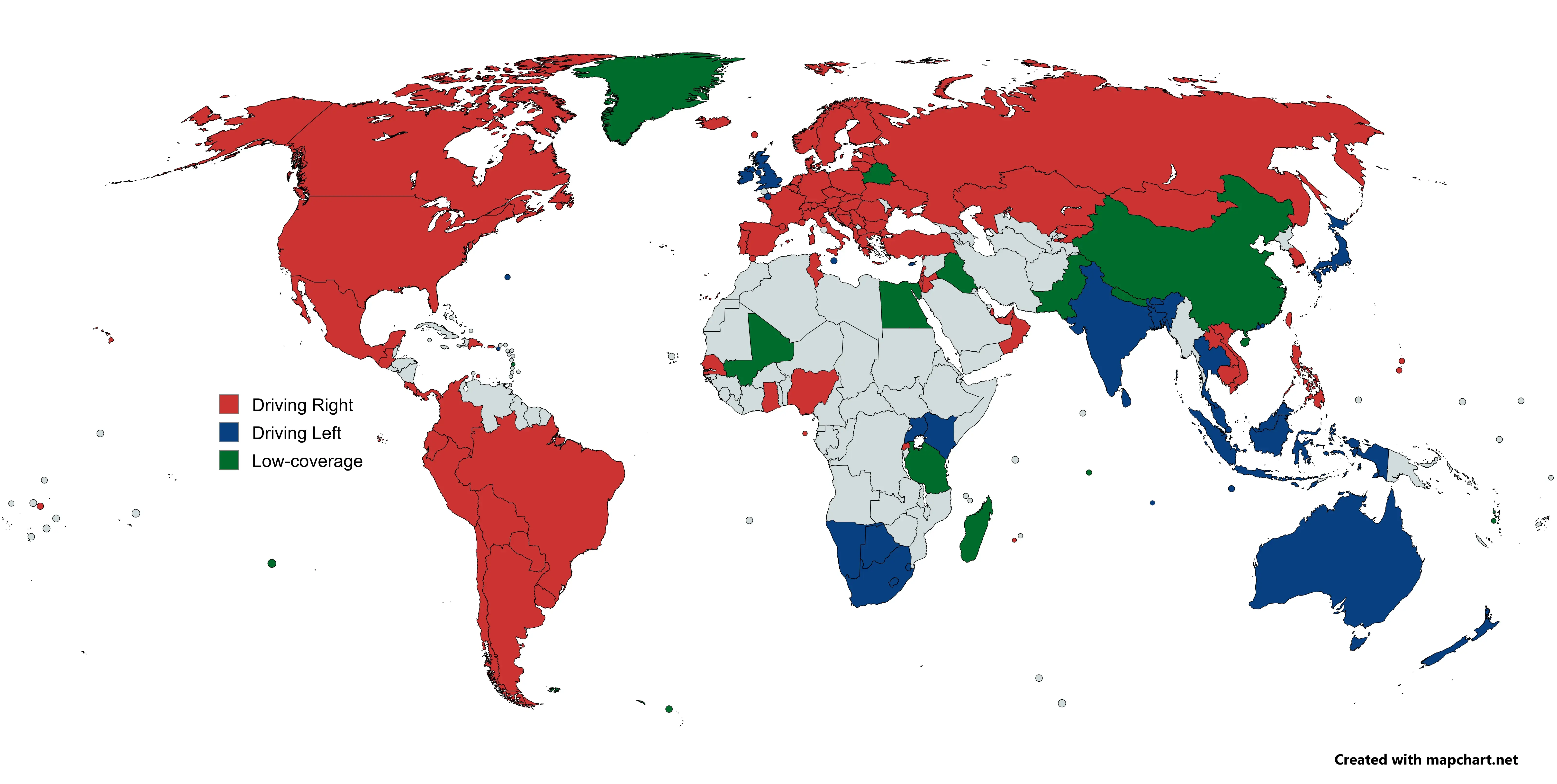
Source: Plonk It Beginner's Guide - Visual reference for driving side identification
Road Lines: The Asphalt Fingerprint
Road markings are one of the most reliable meta clues in Geo Games. Here's what to look for:
North America (USA, Canada):
- Yellow outer line on the road edge (solid or dashed)
- White center lines (often dashed)
- This combination is almost exclusive to North America
Europe:
- White outer lines (solid or dashed)
- White center lines
- Some countries use yellow center lines (France, Italy)
Other Regions:
- Yellow center lines: Common in parts of Asia (Japan, South Korea)
- No lines: Rural areas in many developing countries
Utility Poles: The Grid's Skeleton
Utility poles are surprisingly distinctive:
North America:
- Tall wooden poles with cross-arms
- Often have transformers attached
- Can be very tall in rural areas
Europe:
- Mix of wooden and concrete poles
- Concrete poles common in Eastern Europe
- Often shorter and more compact
Asia:
- Concrete poles very common
- Often have distinctive shapes (Japan's T-shaped poles)
- Can be very tall in urban areas
Bollards: The Silent Sentinels
A very important detail about bollards, particularly in Europe, is the shape and color of the reflectors. Superficially similar bollards can often be distinguished by their reflectors. For example, Spain and Germany both use white bollards with red reflectors, but the reflector shapes differ.
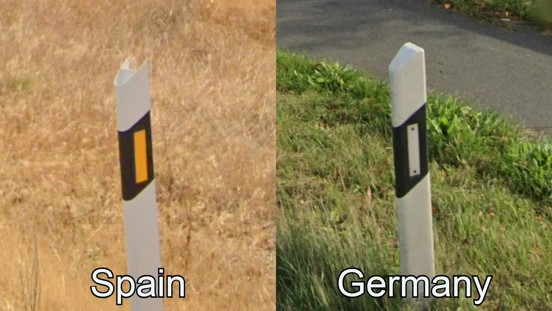
Source: Plonk It Beginner's Guide - Bollard reflector comparison guide
If bollards start feeling like free points instead of noise, go deeper with our World Bollards Guide. It pairs especially well with Geo Solver on harder European rounds.
License Plates: The Telltale Plate
Even when blurry, license plates offer clues:
- Yellow plates: Netherlands, Luxembourg, UK (rear)
- White plates: Most of Europe, USA
- Blue EU strip: European Union countries
- Long and skinny: Netherlands, Luxembourg
- No front plate: Many US states, some European countries
Common Mistakes to Avoid
❌ Mistake: Only looking at road lines, ignoring everything else
✅ Fix: Combine road lines with poles, plates, and signs for maximum confidence.
❌ Mistake: Assuming yellow lines always = USA
✅ Fix: Some countries use yellow center lines. Check if it's the outer edge (USA) or center (France).
Your Practice Mission
Spend one complete game focused entirely on infrastructure:
- Ignore signs and text completely
- Note the road line colors and patterns
- Examine any visible utility poles
- Check license plates on any visible cars
- Make your guess based ONLY on infrastructure
- See how close you get!
This exercise will make you appreciate how much information infrastructure provides.
💡 Pro's Mindset
Pros don't just see "a pole" or "a line." They see systems. "Yellow outer line + tall wooden poles + white license plates = North America, probably USA or Canada." They combine multiple infrastructure clues into a single, confident guess.
4. Master the "Meta"
This is where Geo Game gets interesting. "Meta" refers to clues that aren't about the location itself, but about how Google captured it. These are learnable patterns that can instantly identify countries or regions.
The Google Car: Your Hidden Clue
The Google Street View car itself is a clue. Look for:
Car Color:
- White car: Most common, used worldwide
- Gray car: Some regions use gray vehicles
- Visible roof rack: Can indicate specific countries or regions
Car Equipment:
- Antenna: Visible on some cars, can indicate camera generation
- Mirrors: Shape and position can vary by region
- Roof rack: The famous "Ghana roof rack" is a legendary meta clue
Camera Generation: Reading the Lens
Google has used different camera generations over the years, and each has a visual fingerprint. For an even deeper technical dive, we highly recommend the excellent guide over at Plonk It.
Gen 1 (Very Old Coverage):
- Poor image quality, washed-out sky
- Often blurry
- Common in: Early US coverage, some very old international coverage
Gen 2 (The Famous "Sky Rift"):
- Massive circular "halo" or "rift" in the sky (stitching error)
- This is a golden clue! If you see it, you're almost certainly in:
- North America
- Australia
- New Zealand
- Parts of Western Europe
- Eliminates: Most of Asia, Africa, South America
Gen 3 (Standard Quality):
- Natural colors, clear sky
- Good image quality
- Common in: Japan, South Africa, much of the world
Gen 4 (Current Standard):
- Ultra-crisp, vibrant images
- Perfect circular sun with lens flare
- Slightly oversaturated colors
- Common in: Recent coverage worldwide
Smallcam (Late 2024+):
- As noted in the Plonk It Beginner's Guide, Google released a newer, smaller camera in late 2024, commonly referred to as "smallcam"
- This camera has virtually the same image quality as Generation 4, but is physically smaller
- Currently being used in select regions
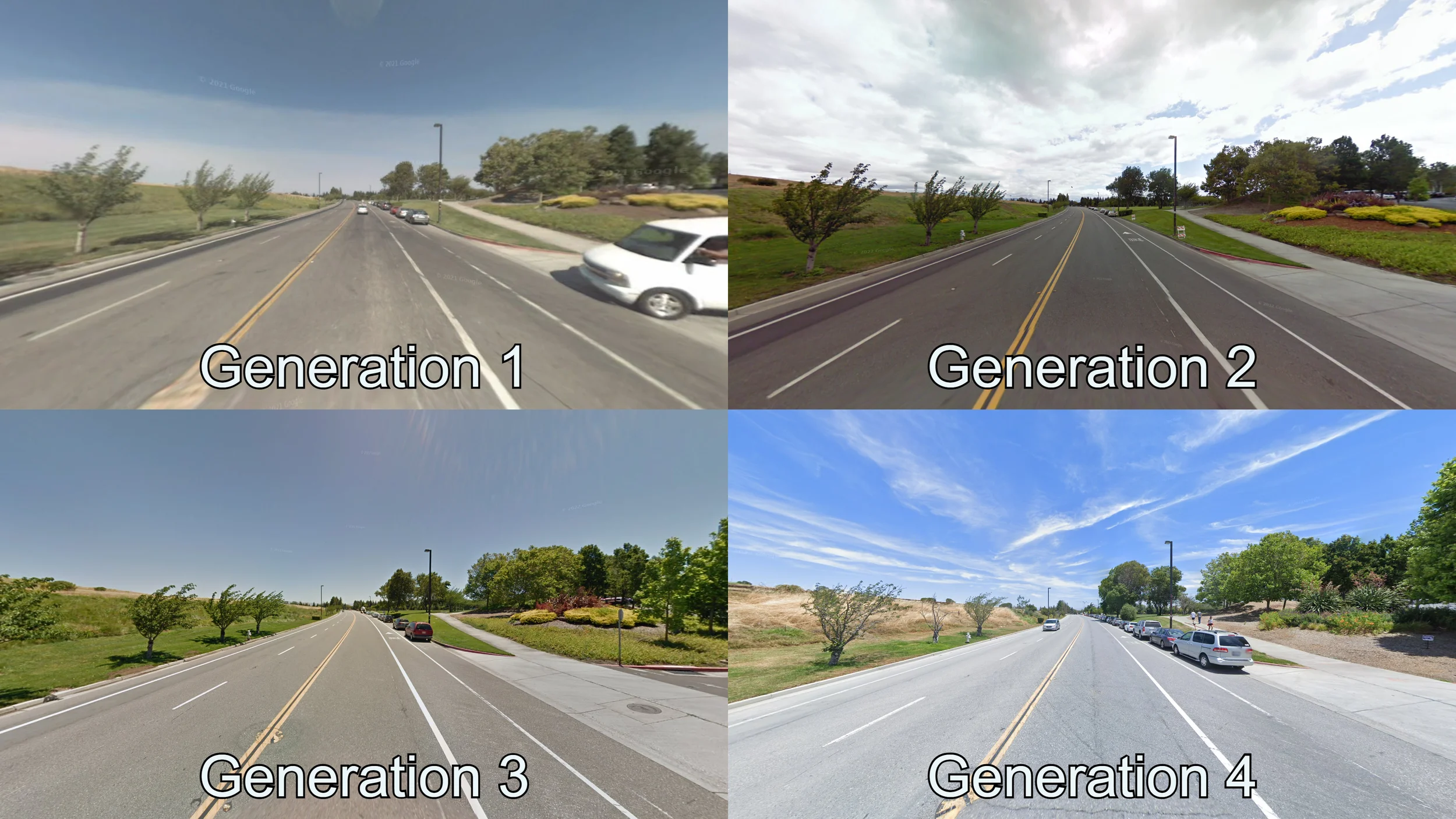
Source: Plonk It Beginner's Guide - Visual reference for camera generation identification
Understanding Google Street View Coverage
It's important to know that Google Street View doesn't cover every country equally. Some countries have extensive coverage, while others have limited or no official coverage. Understanding coverage patterns can help you eliminate impossible locations.
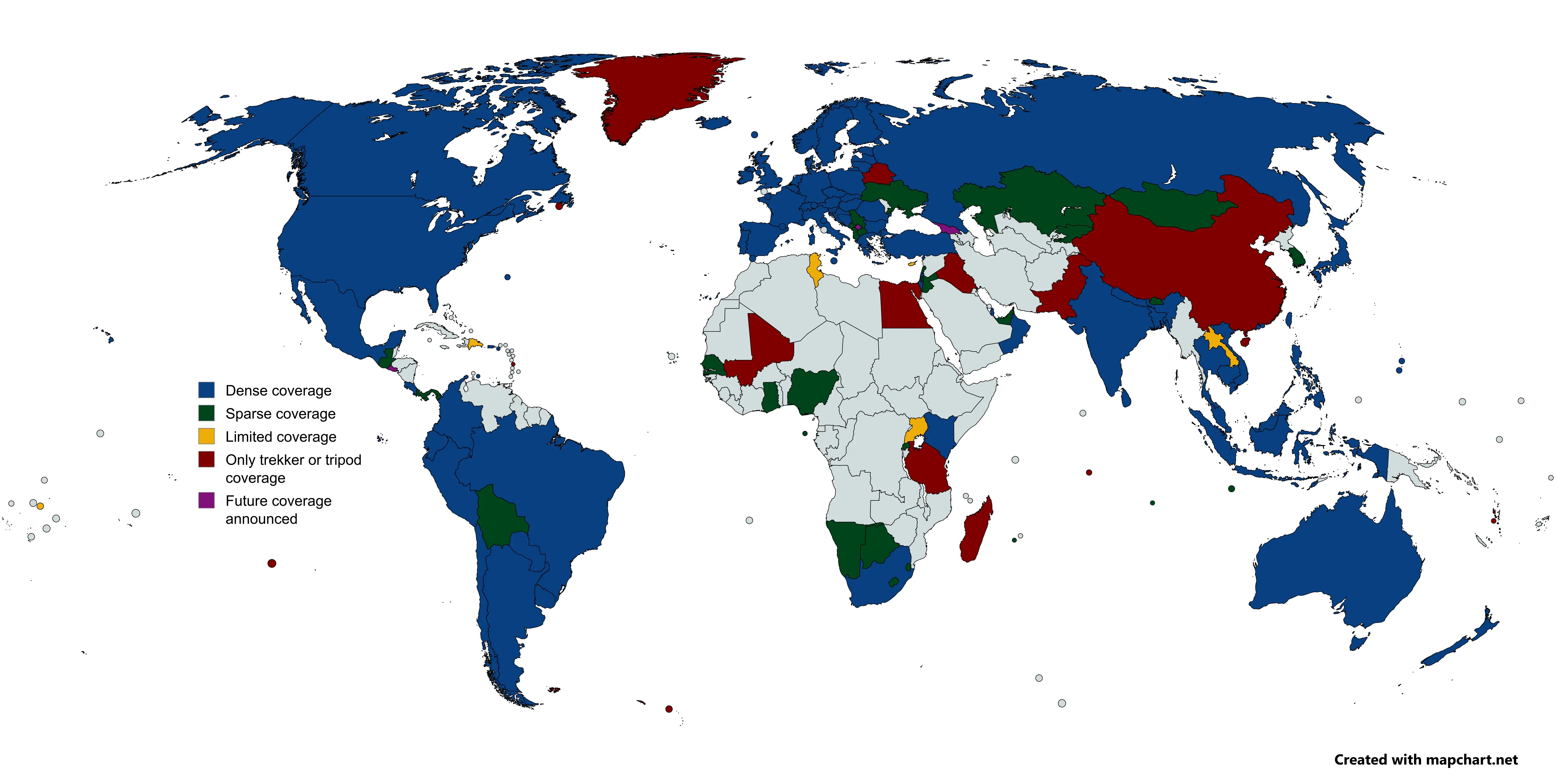
Source: Plonk It Beginner's Guide - Google Street View coverage map
You can check the extent of Street View coverage on this website. Knowing which countries have coverage will help you make more accurate guesses and avoid impossible locations.
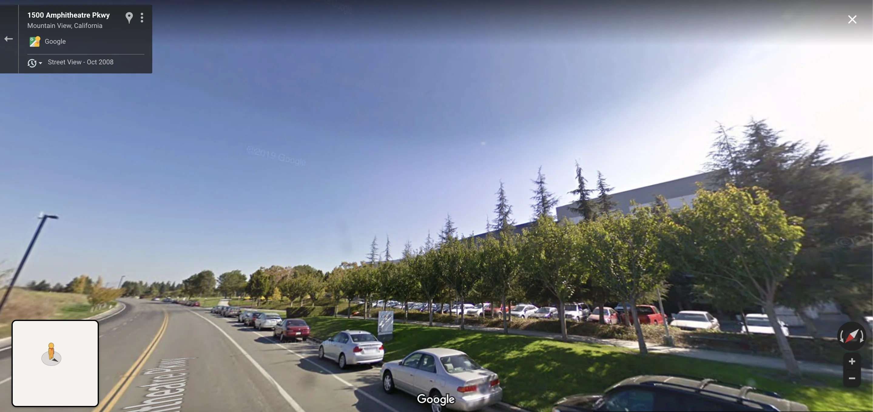
The Gen 2 "sky rift" is one of the most powerful meta clues. If you see this circular halo in the sky, you're almost certainly in North America, Australia, or New Zealand.
Common Mistakes to Avoid
❌ Mistake: Ignoring camera quality because it seems "too technical"
✅ Fix: Camera generation is one of the easiest meta clues to learn. The Gen 2 sky rift is unmistakable once you know what to look for.
❌ Mistake: Assuming all blurry images = old coverage
✅ Fix: Some regions just have lower-quality coverage. Combine camera clues with other evidence.
Your Practice Mission
For the next 10 rounds, add this to your checklist:
- Immediately check the sky for a circular rift (Gen 2)
- Note the overall image quality (crisp = Gen 4, blurry = Gen 1/2)
- Look for the Google car (color, roof rack, equipment)
- Use these clues to narrow down your region guess
You'll be surprised how often camera meta gives you the answer before you even see a sign.
💡 Pro's Mindset
Advanced players see the camera before they see the location. "Sky rift visible? I'm in North America or Australia. No rift, but crisp quality? Recent coverage, could be anywhere. Blurry with washed-out sky? Old US coverage." This meta knowledge eliminates entire continents instantly.
Ready to Practice These Tips?
Upload a Geo Game screenshot and our AI coach will highlight the language clues, infrastructure patterns, and camera meta you may have missed. Learn by doing, not just reading.
Try AI Coach Now
5. Embrace the Process
You won't become a pro overnight. The most important tip is to be patient and enjoy the journey of discovery. Every round, right or wrong, is a new piece of the puzzle.
Building Your Mental Framework
As you practice, you'll start to develop a mental checklist. Top players don't consciously think through every clue—they've internalized a system. Your goal is to build that system through repetition.
The Beginner's Checklist:
- ✅ Sun position (north or south?)
- ✅ Language/script (what writing system?)
- ✅ Landscape (vegetation, soil, terrain)
- ✅ Infrastructure (road lines, poles, plates)
- ✅ Camera meta (generation, car, quality)
- ✅ Combine clues for confident guess
The Intermediate's Checklist:
- All of the above, PLUS:
- Specific bollard types
- Car meta details
- Regional architecture patterns
- Coverage patterns
Common Beginner Mistakes
❌ Moving too much: Beginners often panic and move frantically
✅ Fix: Stay still for 10-15 seconds. Observe first, move second.
❌ Ignoring "obvious" clues: Beginners skip the sun because it seems too simple
✅ Fix: Simple clues are often the most reliable. Use them as your foundation.
❌ Giving up too early: One wrong guess doesn't mean you're bad
✅ Fix: Every round teaches you something. Wrong guesses are learning opportunities.
❌ Not combining clues: Relying on a single clue is risky
✅ Fix: Always combine 2-3 clues for a confident guess. One clue = hint, multiple clues = confirmation.
Your Long-Term Practice Plan
Week 1-2: Foundation
- Focus on language identification
- Practice sun position recognition
- Learn basic road line patterns
Week 3-4: Expansion
- Add infrastructure clues (poles, plates)
- Start noticing camera quality
- Practice combining 2-3 clues
Week 5-6: Refinement
- Learn specific bollard types
- Study car meta patterns
- Practice speed rounds (30 seconds per location)
Ongoing: Mastery
- Learn regional specifics
- Study advanced meta
- Practice competitive formats
The Learning Mindset
Remember: Every pro player was once a beginner. The difference isn't talent—it's practice and systematic learning. Use tools like our AI coach to accelerate your learning, but don't skip the fundamentals.
💡 Pro's Mindset
The best players don't memorize facts—they understand systems. They know that yellow outer lines + tall wooden poles = North America, not because they memorized it, but because they understand the infrastructure patterns. Focus on understanding the "why" behind each clue, not just the "what."
Putting It All Together: A Real Example
Let's walk through a real round using all five tips:
The Scene: You're dropped in a rural area with a two-lane road.
Step 1: Language Detective
- You see a road sign with text
- Script: Latin with unique characters (ł, ą)
- Conclusion: Likely Poland, Czechia, or Slovakia
Step 2: Read the Landscape
- Sun is in the south (Northern Hemisphere)
- Vegetation: Pine trees and birch trees
- Soil: Dark brown, rich
- Conclusion: Temperate climate, Northern Hemisphere
Step 3: Decode Infrastructure
- Road lines: White outer, white center (dashed)
- Utility poles: Concrete, medium height
- Conclusion: European road system
Step 4: Master the Meta
- Camera: Gen 3 or Gen 4 (clear, good quality)
- No sky rift visible
- Conclusion: Recent European coverage
Step 5: Combine Clues
- Latin script with Polish characters + European infrastructure + Northern Hemisphere + Temperate climate = Poland (high confidence)
Result: You make a confident guess in Poland, and you're right! This systematic approach works because you combined multiple clues, not just one.
Frequently Asked Questions
Q: How long does it take to get good at Geo Game?
A: With consistent practice (30 minutes daily), most players see significant improvement in 2-3 weeks. Mastery takes months, but the fundamentals can be learned quickly.
Q: Should I use an AI tool to help me learn?
A: Yes! AI tools like our Geo Solver Coach can accelerate learning by showing you which clues you missed. Use it as a learning tool, not a crutch.
Q: What's the most important tip for beginners?
A: Don't move immediately. Stay still for 10-15 seconds and observe. Most beginners move too much and miss obvious clues.
Q: How do I know if I'm improving?
A: Track your average score over time. If you're consistently getting within 1000km of the correct location, you're on the right track.
Q: Should I focus on one region first?
A: It's helpful to master one region (like Europe) before expanding. But don't ignore other regions completely—play diverse rounds to build general knowledge.
Q: What's the difference between "meta" and regular clues?
A: Regular clues are about the location (language, landscape). Meta clues are about how Google captured it (camera generation, car type). Both are important!
Q: Where can I learn more about specific country clues?
A: The Plonk It Guide is an excellent resource for country-specific guides and beginner-friendly explanations of high-yield meta clues. We also recommend checking out GeoHints.com for a comprehensive collection of infrastructure and meta clues.
Next Steps: Continue Your Learning Journey
Now that you've mastered the fundamentals, here's where to go next:
Recommended Reading
- The Ultimate Learnable Meta Guide - Deep dive into advanced meta clues like bollards, car meta, and camera generations
- The Ultimate Geo Game Checklist - A systematic mental framework used by pro players
- AI Geo Game Guide - Learn how to use AI tools to accelerate your learning
- Plonk It Beginner's Guide - Comprehensive beginner-friendly guide covering game mechanics, gamemodes, and what to look for in-game
- GeoHints.com - Massive collection of infrastructure and meta clues categorized by type
Practice Resources
- Daily Challenges: Play at least one round per day to build consistency
- Speed Rounds: Practice 30-second rounds to improve quick decision-making
- Region-Specific Practice: Focus on one continent per week
Use Our AI Coach
The fastest way to improve is to learn from your mistakes. Upload screenshots from rounds where you were wrong, and our AI will show you which clues you missed.
Ready to Level Up?
Upload a screenshot from your next round and let our AI coach show you the clues you missed. Learn faster with instant feedback on language, infrastructure, and meta clues.
Analyze Your Screenshot
Remember: Every expert was once a beginner. The key to improvement isn't talent—it's consistent practice, systematic learning, and learning from your mistakes. Use these five tips as your foundation, practice daily, and you'll be amazed at how quickly you improve.
Good luck, and happy guessing! 🌍
Tools, Guides, and Articles for This Topic
Move from reading into action with the most relevant solver pages, learnable meta guides, and supporting articles.
Explore the complete GeoGuessr AI hub for ai geoguessr, geoguesser ai, and geoguessr ai solver searches. Compare tools, learn the meta, and pick the best workflow.
Use our advanced GeoGuessr solver for NMPZ, rural rounds, and hard snapshots. Built for players who need deep meta reasoning, not just a broad GeoGuessr AI overview.
Meet the world's most advanced GeoGuessr AI bot. Safer than scripts, our automated AI assistant provides real-time coaching and geographic reasoning without risking your account.
Master the most reliable meta in Geo Games. A complete guide to identifying countries by their traffic bollards.
Master Google Street View car meta for GeoGuessr. Identify countries by snorkels, roof racks, tape, mirrors, antennas, camera generations, and car blur.
Stop guessing, start deducing. This isn't just a list; it's a mental framework used by pro players to deconstruct any Geo Game round with surgical precision.
This definitive guide breaks down every major category of 'learnable meta'—from the Kenya Snorkel to Polish bollards. Stop guessing, start deducting. Learn the secrets pros use to win.