Best Free Picarta Alternatives for Photo Location Finding
Compare free Picarta alternatives for photo geolocation, screenshots, image location finding, reasoning quality, and pricing.
If you are searching for a Picarta alternative, you probably want one of three things:
- a cheaper tool
- a better free option
- more explanation for why the location result is correct
Picarta.ai is a well-known tool for photo geolocation, but it is not the only option. Depending on whether you care most about pricing, speed, reasoning, or screenshot analysis, a different tool may fit better.
This guide compares the best free Picarta alternatives for photo location finding, including both general visual search tools and specialized geolocation tools.
If you already know you want a page dedicated to that intent, our Picarta alternative page is the fastest shortcut. If your need is broader, AI Location Finder is the more general upload-and-locate workflow.
Quick Verdict: Best Picarta Alternatives
| Need | Best alternative |
|---|---|
| Best free starting point for photo location | ReverseImageLocation / GeoSolver |
| Best for famous landmarks or products | Google Lens |
| Best for fast rough OSINT checks | GeoSpy.ai |
| Best second opinion after Google Lens | Bing Visual Search |
| Best for finding duplicate copies online | TinEye |
If your real goal is where was this photo taken, choose a tool that explains visible clues instead of only returning a coordinate or matching image.
The Problem: Why You Need Alternatives
Before diving into the tools, let's understand what makes a good photo location finder:
- Accuracy: Does it get the location right?
- Reasoning: Does it explain how it knows, or just drop a pin?
- Accessibility: Is it free or affordable?
- Reliability: Does it work for "middle of nowhere" locations, not just famous landmarks?
Many tools excel at one or two of these, but few excel at all four. That's why having alternatives matters.
1. ReverseImageLocation: The "Sherlock Holmes" of AI Locators
Best For: Users who want to know why a location is correct (Reasoning & Education)
Price: Free clue preview + affordable unlimited plans
Key Features:
- Structured Reasoning: Unlike simple locators that just drop a pin, ReverseImageLocation acts as an AI Coach. It breaks down the image into clues (architecture, vegetation, road lines, car meta) and explains the deduction process step-by-step.
- Meta Mastery: Specifically trained on geolocation patterns, including camera generations, car equipment, road markings, and regional infrastructure.
- Spoiler-Free Mode: By default, hides the answer so you can read the reasoning first—perfect for learning.
- Educational Focus: Designed to teach you how to identify locations yourself, not just give you coordinates.
How It Works: Upload your photo, and ReverseImageLocation analyzes it in two stages:
- Clues: What it sees (e.g., "Yellow outer road lines", "Red soil", "Left-hand traffic")
- Inference: What those clues mean (e.g., "Yellow outer lines are common in Kenya and Tanzania", "Red soil suggests East African highlands")
Example Analysis:
Here's a real example of how ReverseImageLocation analyzes a photo. Instead of just giving coordinates, it breaks down every clue:
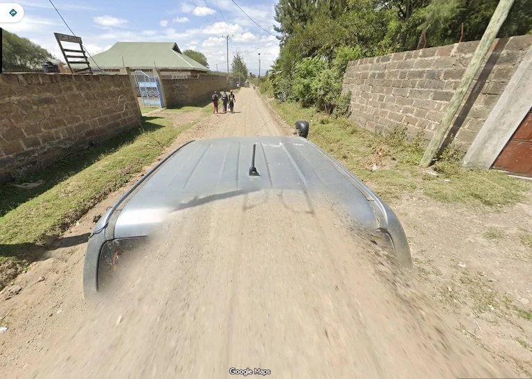
Verdict: The best choice if you care about accuracy, understanding the context, and learning how to identify locations yourself. Try Where Was This Photo Taken →
This is especially true for question-style searches like where was this photo taken, where a raw coordinate is less useful than an explanation you can actually verify.
Pros:
- ✅ Detailed reasoning and explanation
- ✅ Works for both landmarks and "middle of nowhere" locations
- ✅ Generous free tier
- ✅ Educational approach helps you learn
Cons:
- ⚠️ Specialized for geolocation (not for identifying objects or products)
2. Google Lens: The Generalist
Best For: Identifying famous landmarks, products, and text
Price: Completely free
Key Features:
- Integrated into most Android phones and available via Google app on iOS
- Excellent at recognizing famous buildings, monuments, and landmarks
- Can translate text and identify products
- Uses Google's massive image database
How It Works: Point your phone camera at the photo (or upload it), and Google Lens searches its database for visual matches.
Verdict: Great for landmarks and products, but struggles with generic locations.
If you're specifically comparing it as a location tool rather than an object-recognition tool, our Google Lens alternative page breaks down that difference in more detail.
Pros:
- ✅ Completely free
- ✅ Excellent for famous landmarks
- ✅ Integrated into phones
- ✅ Fast results
Cons:
- ❌ Struggles with "middle of nowhere" locations (dirt roads, random streets) where it lacks specific landmark data
- ❌ Doesn't explain how it knows—just shows results
- ❌ Often fails on rural or non-landmark locations
When to Use: When you suspect the photo contains a famous landmark, building, or sign.
3. GeoSpy.ai: The Quick Scanner
Best For: Quick, rough estimates when you need a fast answer
Price: Limited free searches, paid plans available
Key Features:
- Fast processing
- Designed for OSINT (Open Source Intelligence) use cases
- Can handle various image types
How It Works: Upload an image, and GeoSpy attempts to match it against its database of geolocated images.
Verdict: Fast but sometimes inconsistent, with limited explanation of results.
Pros:
- ✅ Fast processing
- ✅ Good for quick checks
- ✅ Some free searches available
Cons:
- ⚠️ Can sometimes hallucinate locations without clear explanation
- ⚠️ Limited reasoning—gives coordinates but not always the "why"
- ⚠️ Free tier is quite limited
When to Use: When you need a quick estimate and don't need detailed reasoning.
4. Bing Visual Search: The Underdog
Best For: When Google Lens fails or you want a second opinion
Price: Completely free
Key Features:
- Microsoft's visual search engine
- Sometimes finds different results than Google Lens
- Can identify landmarks and products
- Integrated into Bing search
How It Works: Similar to Google Lens, but uses Microsoft's image database and algorithms.
Verdict: A solid backup option when other tools fail.
Pros:
- ✅ Completely free
- ✅ Sometimes finds results Google Lens misses
- ✅ Good for landmarks
Cons:
- ❌ Similar limitations to Google Lens (struggles with non-landmark locations)
- ❌ Less widely used than Google Lens
- ❌ Limited reasoning
When to Use: As a backup when Google Lens doesn't find results, or to cross-reference results.
5. TinEye Reverse Image Search: The OSINT Classic
Best For: Finding where an image was originally posted online
Price: Free for basic searches, paid for advanced features
Key Features:
- Finds where images appear on the web
- Can help identify the source of a photo
- Useful for verifying if a photo is from a specific location
How It Works: Upload an image, and TinEye searches the web for matching or similar images, showing where they were posted.
Verdict: Great for finding image sources, but not a direct geolocation tool.
If TinEye is part of your workflow, it is worth pairing this section with our TinEye alternative page because source-finding and location-finding often solve two completely different problems.
Pros:
- ✅ Finds image sources online
- ✅ Useful for verification
- ✅ Free basic searches
Cons:
- ❌ Not a direct geolocation tool—finds where images were posted, not necessarily where they were taken
- ❌ Requires the image to exist online somewhere
- ❌ Limited for original photos not found on the web
When to Use: When you want to find where an image was posted online or verify its source.
Why "Reasoning" Matters: The ReverseImageLocation Advantage
Getting a coordinate is one thing. Understanding why that coordinate is correct is another.
The Problem with "Black Box" Tools: Many geolocation tools give you a pin on a map but don't explain their reasoning. This creates several issues:
- You Can't Verify: If the AI makes a mistake, you have no way to know.
- You Don't Learn: You get the answer but don't understand how to find it yourself next time.
- You Can't Trust: Without reasoning, you can't assess the confidence level of the result.
The ReverseImageLocation Solution: ReverseImageLocation's "Clue Analysis" breaks down the reasoning process, allowing you to:
- Verify the result yourself (e.g., "The AI says it's Japan because of the traffic lights, and I can see them in the photo.")
- Learn the patterns that help identify locations
- Assess confidence based on the quality and quantity of clues
Example: Instead of just getting "Location: Portugal," you get:
Clues Detected:
- Portuguese-style cobblestone (calçada portuguesa)
- White walls with yellow trim (common in Portuguese architecture)
- European license plates visible
- Mediterranean vegetation
Inference: The combination of distinctive Portuguese cobblestone and architectural style strongly indicates Portugal. The yellow trim on white walls is a regional characteristic.
This level of detail transforms a simple coordinate into a learning opportunity.
Comparison Table: Quick Reference
| Tool | Best For | Price | Reasoning | Accuracy | Free Tier |
|---|---|---|---|---|---|
| ReverseImageLocation | Learning & Education | Free + Paid | ✅ Excellent | ✅ High | ✅ Generous |
| Google Lens | Landmarks | Free | ❌ None | ⚠️ Landmarks only | ✅ Unlimited |
| GeoSpy | Quick Checks | Free + Paid | ⚠️ Limited | ⚠️ Variable | ⚠️ Limited |
| Bing Visual Search | Backup Option | Free | ❌ None | ⚠️ Landmarks only | ✅ Unlimited |
| TinEye | Finding Sources | Free + Paid | ❌ N/A | ⚠️ Not geolocation | ⚠️ Limited |
How to Choose the Right Tool
Start with ReverseImageLocation if:
- You want to understand why a location is correct
- You're learning geolocation skills
- You need results for both landmarks and "middle of nowhere" locations
- You value detailed reasoning over speed
Use Google Lens if:
- You suspect the photo contains a famous landmark
- You need results instantly
- You're okay with limited reasoning
Try GeoSpy if:
- You need a quick estimate
- You're doing OSINT research
- You don't need detailed explanations
Use Bing Visual Search if:
- Google Lens didn't find results
- You want to cross-reference multiple tools
Use TinEye if:
- You want to find where an image was posted online
- You're verifying image sources
Real-World Use Cases
Case 1: Old Family Vacation Photo
Scenario: You found an old photo from a family trip but can't remember where it was taken.
Best Tool: Start with ReverseImageLocation for detailed analysis. If it's a famous landmark, also try Google Lens for quick confirmation.
Case 2: Random Internet Meme
Scenario: You saw a funny photo online and want to know where it's from.
Best Tool: ReverseImageLocation for reasoning, or Google Lens if you suspect a landmark. Use TinEye to find where it was originally posted.
Case 3: Geo Game Round Screenshot
Scenario: You're stuck on a Geo Game round and want to learn how to identify similar locations.
Best Tool: ReverseImageLocation—it's specifically designed for this use case and will teach you the patterns.
For players who want the more advanced, hard-round version of that workflow, Geo Solver is the best follow-up page.
Case 4: OSINT Investigation
Scenario: You're doing research and need to verify a photo's location.
Best Tool: ReverseImageLocation for detailed analysis, GeoSpy for quick checks, and TinEye to find image sources.
Conclusion: Don't Stay Wondering
You don't have to stay wondering "Where was this taken?" There are excellent free tools available that can solve this mystery in seconds.
Our Recommendation:
- Start with ReverseImageLocation for a deep, educational analysis that explains the reasoning
- Use Google Lens as a quick backup for famous landmarks
- Cross-reference with other tools if you need additional confirmation
The key difference? ReverseImageLocation doesn't just give you the answer—it teaches you how to find it yourself next time.
Ready to solve your mystery photo? Open AI Location Finder →
Related Articles
- ReverseImageLocation vs. Picarta vs. GeoSpy: Which AI Tool Actually Helps You Win? - A detailed comparison of specialized geolocation AIs
- The Ultimate Guide to Learnable Meta in Geo Games - Learn the patterns that help identify locations
- How Rainbolt Wins: An AI-Powered Analysis - See how experts use systematic reasoning
Tools, Guides, and Articles for This Topic
Move from reading into action with the most relevant solver pages, learnable meta guides, and supporting articles.
Looking for a Picarta alternative? Compare accuracy, reasoning transparency, and hard-case performance when Picarta-style matching struggles on generic or low-context images.
Use reverse image search for location when Google Lens, TinEye, or EXIF fails. Upload a photo and find where it was taken from visual clues.
Upload a photo, picture, or screenshot and find where it was taken. GeoSolver reads visual clues when EXIF, GPS metadata, or Google Lens matches are missing.
Master the most reliable meta in Geo Games. A complete guide to identifying countries by their traffic bollards.
Master Google Street View car meta for GeoGuessr. Identify countries by snorkels, roof racks, tape, mirrors, antennas, camera generations, and car blur.
A deep dive comparing ReverseImageLocation with Picarta, GeoSpy, and ChatGPT to see which tool is best for Geo Game players who want to learn, not just win.
Grok can analyze uploaded images, but it is not a Google Lens-style reverse image search index. See what works, what fails, and the best workaround.