Cardify - Mistake Scan
Scan mistakes into organized study records with AI-powered solutions and feedback.
Upload a photo or screenshot for OSINT image geolocation. Find likely locations from visible clues, reasoning, and evidence you can verify manually.
Review the visual clues behind the location estimate instead of relying on a black-box pin.
Analyze social posts, cropped images, web screenshots, and files with missing EXIF metadata.
Best for public-place verification, journalism, research, and learning. Do not use it to track private people or homes.
Tools and apps you might also like.
Scan mistakes into organized study records with AI-powered solutions and feedback.
Turn voice notes into tasks, reminders, and clean daily plans in seconds.
AI health companion for readiness, recovery, sleep, load, and life context.
Track expenses with voice input, receipt scan, and quick spending insights.
This page is for OSINT-style location verification: upload a photo, screenshot, or saved web image and review the clues that suggest where the image may have been taken.
It is designed for searches like:
If your task is more casual, start with Find Photo Location. If you are thinking in reverse-search terms, use Reverse Image Search for Location.
| Investigation need | Why this page fits |
|---|---|
| A screenshot has no EXIF data | The workflow reads the visible scene instead of file metadata |
| Google Lens returns no useful match | GeoSolver can still reason from roads, vegetation, architecture, terrain, and signs |
| A social post needs location verification | The output includes clues and confidence so you can check the claim manually |
| A unique photo is not indexed online | The image does not need to appear elsewhere on the web |
| You need a defensible hypothesis | The result explains the evidence instead of only showing a coordinate |
OSINT geolocation should be careful and public-interest oriented. Use this workflow for public locations, news verification, research, travel-image checking, and learning visual geolocation.
Do not use it to track private people, identify homes, target individuals, or expose sensitive locations. If a result involves a private residence, a vulnerable person, or an active safety issue, treat the analysis as inappropriate for public sharing.
Road markings, bollards, guardrails, utility poles, curb styles, traffic signs, lane logic, and Street View capture artifacts can all narrow the search area.
Architecture, roofing, fences, paving, storefront formats, public transport details, and street furniture often point toward a country, region, or city.
Vegetation, soil color, terrain, climate, shadows, and horizon shape help support or reject a location hypothesis.
Language, scripts, store signs, number formats, road signs, and public infrastructure labels can provide stronger evidence when visible.
| Method | Best for | Limitation |
|---|---|---|
| Classic reverse image search | Finding exact copies or source pages | Often fails on unique photos or screenshots |
| EXIF/GPS metadata checks | Original camera files | Social platforms usually strip metadata |
| Manual map research | High-confidence final verification | Slow without a good starting hypothesis |
| GeoSolver OSINT workflow | Building a clue-based location hypothesis | Still needs human verification for high-stakes use |
For Reddit, forums, or public research notes, avoid posting exact private addresses. Share the reasoning, the broad area, and the confidence level unless the location is clearly public and safe to disclose.
An outdoor road scene can contain enough evidence even when there is no landmark or readable sign. In the Kenya demo, the result depends on multiple supporting clues rather than a single match.
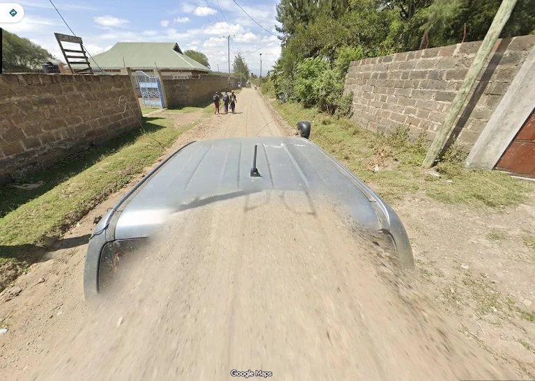
OSINT geolocation works best when several weak clues support the same region.
Use the result as the first rung, not the final proof.
| Evidence level | What to check |
|---|---|
| AI hypothesis | Country, region, coordinates, confidence, and stated clues |
| Visible clue review | Signs, road layout, architecture, vegetation, terrain, shadows, and vehicle context |
| Map and satellite check | Roads, coastline, hills, water, land use, building density, and terrain |
| Local references | Street View, business photos, travel photos, municipal pages, and local news |
| Confidence statement | What is confirmed, what is likely, and what remains uncertain |
For a deeper checklist, use How to Verify AI Image Geolocation Results.
Use this structure when sharing a result in notes, a newsroom workflow, or a public research thread:
Yes. It supports OSINT-style image geolocation by turning visible clues into a location hypothesis with reasoning. It should still be paired with manual verification.
Yes. The workflow is built for screenshots, social images, and metadata-stripped photos where the visible scene is the main evidence.
Yes, when the target is a public-interest location and you verify the result independently. Use cautious confidence language and avoid exposing private people or homes.
No. Google Lens and TinEye are strongest when an indexed visual match exists. This page focuses on location reasoning from the image itself.
Our AI analyzes visual clues to estimate where the image was taken
Drag, paste, or click to upload your image